![]()
If the risk address is in a state with no state-sponsored windpool eligibility, Group II Zone, or distance information, the corresponding fields will indicate that no results were found for the search criteria.
The LOCATION® Wind Report provides data from a suite of ISO services that are crucial in helping you underwrite and rate risks in areas susceptible to wind exposure. The report provides the distance from a location to the ocean and nearest body of water, so you can better assess potential for damage from wind or storm surges. It also identifies locations in windpool zones and gives you the corresponding ISO personal/commercial property territory code and the ISO Commercial Group II Zone, so you can be sure you are rating and reporting that risk correctly. For risks in Florida, the report also provides territory codes for Citizens Property Insurance Corporation.
Abbreviated reports will display only windpool eligibility and ISO Commercial Group II Zone fields. Windpool eligibility, Group II Zones, and distance services do not apply in every state.
|
|
If the risk address is in a state with no state-sponsored windpool eligibility, Group II Zone, or distance information, the corresponding fields will indicate that no results were found for the search criteria. |
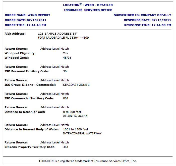
The Wind Report provides the following information:
|
Risk Address |
The address used to match against the database. |
|
Return Source |
Shows whether the match is on an address level or a ZIP-Code level. The report shows a Return Source for each of the data elements listed below.
|
|
Windpool Eligibility |
Shows whether the risk is eligible to participate in state-sponsored insurance pools. Windpool zones are coastal areas eligible for participation in state-sponsored insurance pools. Windpool and beach plan associations grant credits to insurers writing risks within specified zones. |
|
Windpool Zone |
In select states, displays additional windpool-specific zone information that further defines coverage. The report returns the following zone names in windpool-eligible areas of the indicated states: Alabama — Displays Zone 1, Zone 2, Zone 3, or Zone 4. Florida — Displays two territory designations separated by a slash (/). The first code is for dwelling forms and the second is for all other policy forms. (For example, the field might display 47/37.) Dwelling forms are for residential properties only, including dwellings, mobile homes, and residential condominiums. All other includes forms covering commercial, commercial-residential, and special class (including residential special class) properties, as well as builders risk. Mississippi — Displays A, B, C, or D. North Carolina — Displays Beach or Coastal. South Carolina — Displays 1 or 2. No zone information will display if the risk is not within an eligible windpool zone. |
|
ISO Personal Territory Code |
Displays the ISO personal property territory code for the address. Personal territories are specified geographic areas, such as cities, towns, counties, or ZIP Codes. When varying loss experience indicates the need for a further breakdown, the territory may consist of a smaller geographic area. |
|
ISO Group II Zone – Commercial |
Displays the ISO Group II Zone for the address shown. The Group II Zone is derived from historical loss data and/or specific designated regions used to rate loss cost. |
|
ISO Commercial Territory Code |
Displays the ISO commercial property territory code for the address shown. Commercial territories are specified geographic areas, such as cities, towns, counties, or ZIP Codes. When varying loss experience indicates the need for a further breakdown, the territory may consist of a smaller geographic area. |
|
Distance to Ocean or Gulf |
Displays the name of the nearest ocean or gulf and the distance value from the risk address to that ocean or gulf. The report illustrates these distances in ranges, such as 0 to 500 feet or 1 mile to less than 2 miles. If the distance is greater than 30 miles, the report will not display the name of the nearest ocean or gulf. |
|
Distance to Nearest Body of Water |
Displays the name of the nearest body of water and the distance from the risk address to that body of water. The report illustrates these distances in ranges, such as 0 to 500 feet or 1 mile to less than 2 miles. If the distance is greater than 30 miles, the report will not display the name of the nearest body of water. |
|
Citizens Property Territory Code |
Displays territory codes for Citizens Property Insurance Corporation. Citizens is an insurer created by the Florida legislature to serve the needs of Florida homeowners who cannot find coverage in the open, private insurance market. |
The report shows the distance to the ocean, gulf, or nearest body of water in the following increments:
|
|
|
|
|
|
|
|
|
|
|
|
|
|
|
|
The Wind Report shows the distance from the risk address to the nearest body of water. If there are two or more bodies of water with the same distance value, the report shows only the body with the potential to cause the most severe and frequent damage. The following list shows the types of bodies of water in order of their potential to cause severe and frequent damage.
|
1 |
Gulf |
10 |
Delta |
19 |
Bayou |
|
2 |
Bay |
11 |
Strait |
20 |
Lagoon |
|
3 |
Intracoastal waterway |
12 |
Channel |
21 |
Basin |
|
4 |
Harbor |
13 |
Cape |
22 |
Arm |
|
5 |
Sound |
14 |
Cover |
23 |
Reach |
|
6 |
Inlet |
15 |
Port |
24 |
Thoroughfare |
|
7 |
Mouth |
16 |
Pass |
25 |
Stream |
|
8 |
River |
17 |
Passage |
26 |
Creek |
|
9 |
Lake |
18 |
Canal |
27 |
Slough |